
China is making preparations to make its BeiDou Navigation Satellite System (BDS) available to global users, according to a white paper released by the Chinese government on Thursday, June 16, the Xinhua News Agency reported.
The State Council Information Office discussed the country’s action plan and a three-step strategy to develop the BDS with the aim to deploy 35 satellites around 2020 for commercial use globally.
Before 2020, the basic services of the BDS will be available to nations along the Belt and Road and its neighboring countries.
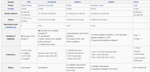
Users in the Asia-Pacific region currently enjoy the system’s open services free of charge, which covers the area between 55 degrees north latitude and 55 degrees south latitude, and between 55 and 180 degrees east longitude. It has a positioning accuracy of less than 10 meters, with velocity measurement accuracy of less than 0.2 meters per second, and timing accuracy of less than 50 nanoseconds
The second generation of the system, officially called the BeiDou Navigation Satellite System (BDS) and also known as COMPASS or BeiDou-2, will be a global satellite navigation system consisting of 35 satellites, and is under construction as of January 2015. It became operational in China in December 2011, with 10 satellites in use, and began offering services to customers in the Asia-Pacific region in December 2012. It is planned to begin serving global customers upon its completion in 2020
In-mid 2015, China started the build-up of the third generation BeiDou system (BDS-3) in the global coverage constellation. The first BDS-3 satellite was launched 30 September 2015. As of March 2016, 4 BDS-3 in-orbit validation satellites have been launched.
According to China Daily, fifteen years after the satellite system was launched, it is now generating $31.5 billion for major companies such as China Aerospace Science and Industry Corp, AutoNavi Holdings Ltd, and China North Industries Group Corp.
There are two levels of service provided — a free service to civilians and licensed service to the Chinese government and military. The free civilian service has a 10-meter location-tracking accuracy, synchronizes clocks with an accuracy of 10 nanoseconds, and measures speeds to within 0.2 meters per second. The restricted military service has a location accuracy of 10 centimeters, can be used for communication, and will supply information about the system status to the user. To date, the military service has been granted only to the People’s Liberation Army and to the Military of Pakistan.
The statistical analysis of the 6-h predicted orbits show that the radial and cross root mean square (RMS) values are smaller than 10 cm for BeiDou and Galileo, and smaller than 5 cm for both GLONASS and GPS satellites, respectively. The RMS values of the clock differences between real-time and batch-processed solutions for GPS satellites are about 0.10 ns, while the RMS values for BeiDou, Galileo and GLONASS are 0.13, 0.13 and 0.14 ns, respectively. The addition of the BeiDou, Galileo and GLONASS systems to the standard GPS-only processing, reduces the convergence time almost by 70 %, while the positioning accuracy is improved by about 25 %. Some outliers in the GPS-only solutions vanish when multi-GNSS observations are processed simultaneous. The availability and reliability of GPS precise positioning decrease dramatically as the elevation cutoff increases
SOURCES- Wikipedia, Journal of Geodesy, Xinhua

Brian Wang is a Futurist Thought Leader and a popular Science blogger with 1 million readers per month. His blog Nextbigfuture.com is ranked #1 Science News Blog. It covers many disruptive technology and trends including Space, Robotics, Artificial Intelligence, Medicine, Anti-aging Biotechnology, and Nanotechnology.
Known for identifying cutting edge technologies, he is currently a Co-Founder of a startup and fundraiser for high potential early-stage companies. He is the Head of Research for Allocations for deep technology investments and an Angel Investor at Space Angels.
A frequent speaker at corporations, he has been a TEDx speaker, a Singularity University speaker and guest at numerous interviews for radio and podcasts. He is open to public speaking and advising engagements.