
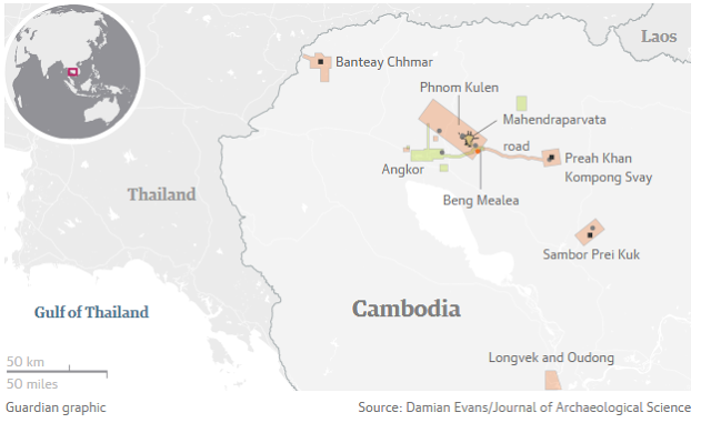
Archaeologists in Cambodia have found multiple, previously undocumented medieval cities not far from the ancient temple city of Angkor Wat, the Guardian can reveal, in groundbreaking discoveries that promise to upend key assumptions about south-east Asia’s history.
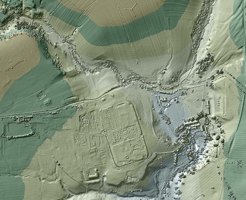
The Australian archaeologist Dr Damian Evans, whose findings will be published in the Journal of Archaeological Science on Monday, will announce that cutting-edge airborne laser scanning technology has revealed multiple cities between 900 and 1,400 years old beneath the tropical forest floor, some of which rival the size of Cambodia’s capital, Phnom Penh.
Some experts believe that the recently analysed data – captured in 2015 during the most extensive airborne study ever undertaken by an archaeological project, covering 734 sq miles (1,901 sq km) – shows that the colossal, densely populated cities would have constituted the largest empire on earth at the time of its peak in the 12th century.
The survey uncovered an array of discoveries, including elaborate water systems that were built hundreds of years before historians believed the technology existed. The findings are expected to challenge theories on how the Khmer empire developed, dominated the region, and declined around the 15th century, and the role of climate change and water management in that process.


LIDAR has also been used to find lost Roman roads.
In 2015 there was the discovery of a larger version of Stonehenge
On September 7, 2015, researchers announced they have discovered evidence for the remains of a major new prehistoric stone monument, buried below ground less than 3 kilometers (1.86 miles) from Stonehenge. The site is 15 times the size of Stonehenge. The Stonehenge Hidden Landscapes Project team – a group of British archaeologists – used multi-sensor technologies to reveal evidence for a row of about 90 standing stones hidden beneath the bank of what is now called Durrington Walls, a super-henge in Britain.
Durrington Walls is one of the largest known henge monuments measuring 500 meters (0.3 miles) in diameter. It’s thought to have been built around 4,500 years ago. The word henge refers to a particular type of earthwork, typically consisting of a roughly circular or oval-shaped bank with an internal ditch surrounding a central flat area. Henges may have contained (or may still contain) ritual structures such as stone circles, timber circles and coves.

Artist’s concept of how the stones at Durrington Walls may have been positioned. Image via LBI ArchPro, Juan Torrejón Valdelomar, Joachim Brandtner
Durrington Walls may have contained an ancient village at one time. The henge surrounds several smaller enclosures and timber circles and is associated with a recently excavated later Neolithic settlement.
The Stonehenge Hidden Landscapes Project team, using non-invasive geophysical prospection and remote sensing technologies, discovered evidence for a row of up to 90 standing stones, some of which may have originally measured up to 4.5 meters (14.8 feet) in height. Many of these stones have survived because they were pushed over and the massive bank of the later henge raised over the recumbent stones or the pits in which they stood.
These stones have been hidden for millennia.

Artist’s concept of standing stones beneath Durrington Walls super-henge. Image via LBI ArchPro, Juan Torrejón Valdelomar, Joachim Brandtner

SOURCES – Guardian UK, Earth and sky, Journal of Archeological Science,

Brian Wang is a Futurist Thought Leader and a popular Science blogger with 1 million readers per month. His blog Nextbigfuture.com is ranked #1 Science News Blog. It covers many disruptive technology and trends including Space, Robotics, Artificial Intelligence, Medicine, Anti-aging Biotechnology, and Nanotechnology.
Known for identifying cutting edge technologies, he is currently a Co-Founder of a startup and fundraiser for high potential early-stage companies. He is the Head of Research for Allocations for deep technology investments and an Angel Investor at Space Angels.
A frequent speaker at corporations, he has been a TEDx speaker, a Singularity University speaker and guest at numerous interviews for radio and podcasts. He is open to public speaking and advising engagements.