

Neos and Lockheed Martin are building a unique gravity sensor, which is so advanced that it could find a 10-meter tall hill buried 1 km below the earth’s surface. The technology could find an armored truck full of gold 20 m below the earth, purely by sensing the effect the bullion imparts on the local gravity field.
The new technology, called Full Tensor Gradiometry (FTG) Plus, has 20 times the sensitivity and 10 times greater bandwidth than current gravity gradiometers. Lockheed Martin is building the prototype specifically to detect natural resources from aircraft owned and operated by Neos.
“FTG Plus transforms what we can do and what we can see from the air,” said Jonathan Faiman, chairman of Neos. “Remote sensing is going to dominate the exploration market, and with this sensor Neos will have the most advanced in the world. It will enable us to image resources cleaner, quicker and at a lower cost to our customers.”
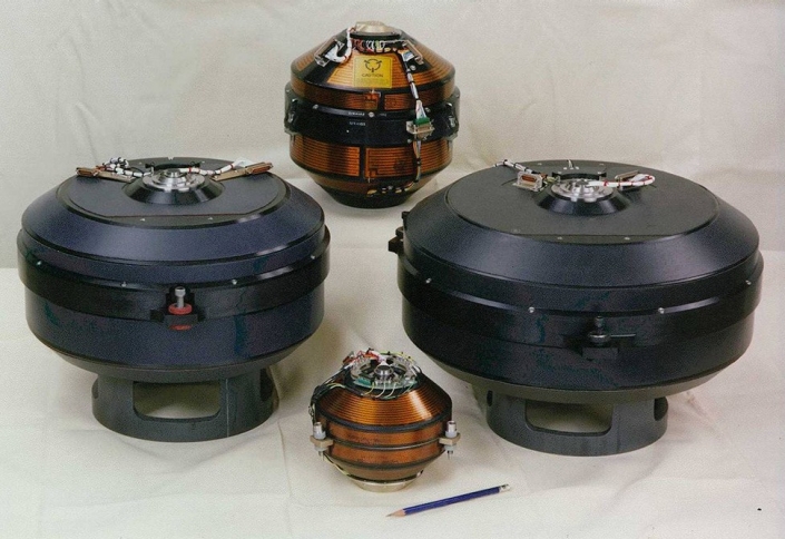
Lockheed Martin builds multiple versions of gravity gradiometer instruments, like those (top center) used in Full Tensor Gradiometer (FTG) systems.
“The advances we will make here are extraordinary. One of the reasons is that in the past we and competitors have used military hardware, modified for geophysical survey purposes,” said Gregory Paleolog, FTG Plus program lead for Neos. “FTG Plus is the first time Lockheed Martin has specifically built a sensor for our precise use and needs. That is a fundamental change; it is an entirely new design for us, and we have exclusive rights to use it.”
Neos has exclusive use of the technology for applications related to oil, gas and mining and will use FTG Plus in its fleet—either Twin-Engined Basler BT-67s, single turbine engine Cessna C-208B Caravan aircraft or Reims-Cessna F406 twin turbine airplanes. The sensors can also be used in helicopters.
The technology has the potential to change the way governments, energy ministries and exploration teams find valuable resources, and ultimately lead to faster, more informed decisions about where to explore, lease and drill.
“At a time when so much marine seismic equipment is being cold-stacked, we will be able to use non-seismic technology with a new sensor 20 times better than anything we have ever seen before,” Paleolog said. “This means we will find more resources, quicker and with more accuracy than ever before. It will be transformative.”
Gravity gradiometry is the study and measurement of variations in the acceleration due to gravity. The gravity gradient is the spatial rate of change of gravitational acceleration. Full tensor gradiometers measure the rate of change of the gravity vector in all three perpendicular directions giving rise to a gravity gradient tensor
Gravity gradiometry is used by oil and mineral prospectors to measure the density of the subsurface, effectively the rate of change of rock properties. From this information it is possible to build a picture of subsurface anomalies which can then be used to more accurately target oil, gas and mineral deposits. It is also used to image water column density, when locating submerged objects, or determining water depth (bathymetry). Physical scientists use gravimeters to determine the exact size and shape of the earth and they contribute to the gravity compensations applied to inertial navigation systems.
SOURCES- Worldoil, Wikipedia, lockheed

Brian Wang is a Futurist Thought Leader and a popular Science blogger with 1 million readers per month. His blog Nextbigfuture.com is ranked #1 Science News Blog. It covers many disruptive technology and trends including Space, Robotics, Artificial Intelligence, Medicine, Anti-aging Biotechnology, and Nanotechnology.
Known for identifying cutting edge technologies, he is currently a Co-Founder of a startup and fundraiser for high potential early-stage companies. He is the Head of Research for Allocations for deep technology investments and an Angel Investor at Space Angels.
A frequent speaker at corporations, he has been a TEDx speaker, a Singularity University speaker and guest at numerous interviews for radio and podcasts. He is open to public speaking and advising engagements.