

DARPA is creating a GPS-like technology that works in the deep ocean called Positioning System for Deep Ocean Navigation, or POSYDON.
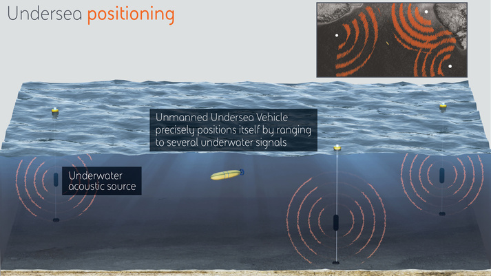
The Global Positioning System (GPS) is the predominant means of obtaining positioning, navigation, and timing (PNT) information for both military and civilian systems and applications. However, the radio frequency basis for GPS also means that its signals cannot penetrate seawater, and thus undersea GPS is effectively denied. The Positioning System for Deep Ocean Navigation (POSYDON) program aims to develop an undersea system that provides omnipresent, robust positioning across ocean basins. By ranging to a small number of long-range acoustic sources, an undersea platform would be able to obtain continuous, accurate positioning without surfacing for a GPS fix. Phase I of the program focuses on accurately modeling the signal propagation channel, and Phase II focuses on developing the signal waveform. A complete positioning system is scheduled to be demonstrated in Phase III.
DARPA selected BAE Systems to develop POSYDON
DARPA envisions that the POSYDON program will distribute a small number of acoustic sources, analogous to GPS satellites, around an ocean basin.
Underwater acoustic signal propagation channels present a number of challenges:
• Time-varying multipath propagation and multipath delay
• Doppler spread due to platform motion relative to the acoustic source(s) and ocean environment
• Bandwidth-limited signals
• Convergence zones
• Tomographic calibration of a region as a function of time/environmental variability
There are some GPS radio systems that can work in shallow waters, but DARPA wants to go into the deep ocean with submarine drones. Submarine navigation is one of the most complex and dangerous ventures in the military because, to get a precise location on one, the vessel has to eventually emerge from the water to catch a radio signal. Even access to a GPS can be blocked by enemy jamming.
Currently, submarines are outfitted with a “very large and very expensive inertial measurement unit,”Niedzwiecki. says. It basically remembers the submarines last known location and keeps track of its diving depth and forward movement. This, of course, is not the nearly as precise as a GPS system.
Drone subs operating under POSYDON could locate underwater mines, track enemy subs and perform other critical tasks larger manned submarines cannot, according to The National Interest:
* Number of small drones could send out an acoustic ping and then analyze
* Drone swarms update ships and submarines

Brian Wang is a Futurist Thought Leader and a popular Science blogger with 1 million readers per month. His blog Nextbigfuture.com is ranked #1 Science News Blog. It covers many disruptive technology and trends including Space, Robotics, Artificial Intelligence, Medicine, Anti-aging Biotechnology, and Nanotechnology.
Known for identifying cutting edge technologies, he is currently a Co-Founder of a startup and fundraiser for high potential early-stage companies. He is the Head of Research for Allocations for deep technology investments and an Angel Investor at Space Angels.
A frequent speaker at corporations, he has been a TEDx speaker, a Singularity University speaker and guest at numerous interviews for radio and podcasts. He is open to public speaking and advising engagements.